
“Soon after three o’clock on the afternoon of April 22nd, 1973, a 35-year-old architect named Robert Maitland was driving down the high-speed exit lane of the Westway interchange in central London. Six hundred yards from the junction with the newly built spur of the M4 motorway, when the Jaguar had already passed the 70 m.p.h. speed limit, a blow-out collapsed the front nearside tyre.”
***
This how J.G. Ballard introduces us to the London of Concrete Island (1974), a novel in which principal character Robert Maitland is stranded on an island created by intersecting motorways. Maitland’s concrete island does not exist in our timeline, but something like it might have done had politics turned out differently in the 1970s [1].
Ten days before Maitland’s fictional crash, Labour won the election for the Greater London Council (GLC) on a manifesto promising the cancellation of the London Ringways project that threatened to carve the metropolis into an archipelago of Concrete Islands.
I have always been intrigued by the idea of the Ringways, and the Ballardian alternative London that they might have brought into existence. I was therefore pleased about the publication this year of the SABRE might-have-been map of what London’s road network would have looked like had the full project been implemented.
The map is a transgressive work of art that dreams of a different city. It involved an awful lot of work for its authors. Behind the lines on the map lies a great deal of archival research, because the Ringway plan was not contained in a single detailed document until now. There was not even a single organisation in charge: the outer rings were the responsibility of central government while the inner two were GLC projects.
The Ringway plan was a product of the 1960s [2]. Ringway 1, also called the Motorway Box, would have been the innermost, the compass points on its route being Camden Town, Blackwall, Brixton and West Kensington. Much of it would have run above ground level “on stilts”. Ringway 2 would have run largely where the North Circular is now, but significantly further out than the laughable South Circular, running for instance through Thornton Heath and Earlsfield.
Ringway 3 would be the heavy-duty principal route around the city for non-London traffic, running from Enfield in the north to Purley and Jim Ballard’s Shepperton in the South before looping back through Hayes and Bushey. Ringway 4 was further out, in line with the present M25 in the south and west but a gentler parkway-style road through Hertfordshire in the north. They would have spurs and radials connecting them, but the Ringway plan was less extreme than the motorway plans of the 1950s that envisaged the M1 starting at Marble Arch.
The consensus on building the inner Ringways collapsed surprisingly rapidly, reflected in London Labour’s about-turn between 1970 and 1973. The brutal look of the Westway, London’s innermost urban motorway, did not make public opinion warm to the larger Ringways.
Michael Heseltine opened this Wilson-era project in July 1970, just after Edward Heath’s government took office. It ran for the most part as an elevated highway alongside railways, following an existing seam in the city as most of the Ringways would have, but it still created a bleak barrier at street level. Residents of Acklam Road in North Kensington looked out onto the flyover from their first-floor windows, the noise and pollution inescapable. The residents were rehoused in 1971 but their protest in 1970 had a lasting impact in focusing attention away from the shiny futurism of the car city towards the human and environmental cost.
Contemporary authors, before the planners and London politicians rejected the Ringways, found something inherently dark and dystopian in the image of an urban motorway. J. G. Ballard made it his territory in Crash (1973) where the North London Radial, one of the more speculative add-ons to the Ringways, features. He did it again in Concrete Island, a world of the roar of depersonalised traffic, direction signs lit by sickly sodium lighting and the ruined spaces in between.
Yet there is a strange allure about the Ballardian urban motorway for the author, his characters and I think ourselves. Maitland never leaves the island although he clearly could, and this perverse love is made all too literal in Crash. Will Self, influenced by Ballard, is one of the few to be open about his affection for the Westway. I remember watching a hallucinatory short film about Self driving along the little elevated highway back in the day when it was legal to do it at 70 mph.
In Martin Amis’s Dead Babies (1975) the jaded characters visit a theatre – implicitly the Gaumont State in Kilburn – hemmed in by a flyover. They see violent entertainment on a theme of steely art-terrorists attacking a vaudeville performance – a metaphor for the motorway’s bulldozing of the tired urban fabric and the wider attack of the new upon the old.
There is another important piece of dystopian 1970s motorway writing. I wonder if the collective imagination, at least among people who are involved in writing about this sort of thing and making policy, is influenced by Robert Caro’s magnificent book The Power Broker (1975). It is a biography of Robert Moses, who, without being elected to anything, navigated through the maze of organisations that made up New York government and shaped the physical landscape of the city.
Moses was, in Caro’s persuasive account, almost obsessive in his belief that cars were the future. He sliced the city with highways. There is a particularly vivid chapter, The Meat Ax, which describes how the Cross Bronx Expressway was rammed through a densely populated urban area, its straight-line course refusing any attempt to mitigate the impact on the surrounding neighbourhoods. It directly displaced 40-60,000 people.
Caro describes how crime and blight spread in the area south of the Cross Bronx, and even without knowing about the toxic effects of the lead fumes billowing from the highway he identified it as a cause as well as a marker of the geographical extent of the collapse of the South Bronx.
***
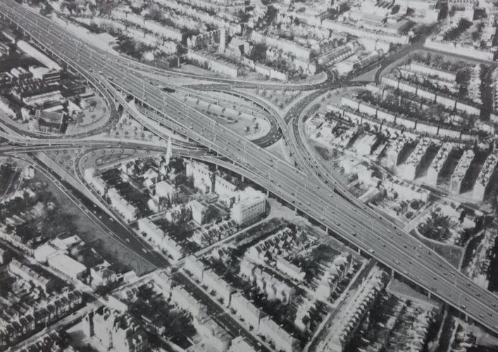
The Ringways are usually seen now as a bullet, or a meat axe, that London dodged. But I’m not so sure. I’m not going to defend them, of course. The models for Brixton town centre were deranged, and the massive interchange that would have destroyed Dalston is a nasty-looking thing (main photo). There is open space in London where I have wandered happily that would not exist in the Ringways timeline – the fields along the Wandle between Earlsfield and Wandsworth, a chunk of Victoria Park.
The complete programme would have demolished around 30,000 houses, although cutting out the South Cross Route and its access roads would have reduced that toll considerably. We now know more than we did in the 1960s about how urban highways generate more traffic. My knee twitches in opposition when I hear about London road plans now, and I don’t drive – but then again, neither could Robert Moses.
If London had built the Ringways, my heretical opinion is that we would have got used to them. London would still be London. Our mental maps of the capital would incorporate them without thinking about the planning decisions that had created them. They would just be there.
They would not have been the first body modifications to London either, or the most disruptive. The mid-19th Century construction of the great railway termini and their approach lines involved a larger number of people being displaced than the Ringways, in a city with a smaller population. The impact of displacement was much worse. Who admires St Pancras and King’s Cross and thinks about the long-ago cost in homelessness and misery when they were built and the locals were pushed out without compensation to live in squalor?
Even smaller projects involved what now seem colossal amounts of displacement. Holborn Viaduct alone threw 2,000 people out of their homes in the 1860s. Ramming Kingsway and Aldwych through a densely populated section of central London at the end of the 19th and beginning of the 20th Centuries cost 3,700 people their homes, although – a sign of social change and the progressive aspirations of the London County Council – they were mostly rehoused elsewhere.
The Ringway plans reveal one of the eternal features of urban infrastructure – there is more solicitude over wealthy areas than there is for places where poorer people live. Ringway 1 would have run in a tunnel under Belsize Park. The planners agonised over the idea of ploughing Ringway 2 through Blackheath and wondered about putting it in a tunnel instead. By contrast, Brixton and Camden Town received no such consideration.
I once lived not far from the Westway. I realise with a shudder that next year my arrival there in 1998 will be on the halfway point of the Westway’s life, slightly longer than my own. The road did not impinge much and most of the time, a bit like tinnitus, you could forget it was there. The mitigation of the Westway’s impact was a long story, involving a lot of hard work led by the Westway Trust (formerly North Kensington Amenity Trust) whose origins are in the protest movement against the Westway.
I now live not far from a cancelled stretch of the northern section of the Motorway Box, and even closer to the Camden Town Bypass, one of its access routes. I’m glad, of course, that neither was built, but I still wonder what might have been.
The Camden section was one of the most complex parts of the Ringway. The main course of the planned road would have swept along the north of Camden Town just where the market is today, forming the top deck of a double-deck flyover with criss-crossing access ramps between the decks and the surface streets.
It would certainly have altered the course of local history, but would it have prevented the Camden we know from existing? Camden Market was founded in 1974, but surely the groundswell for a craft market would have surfaced somewhere in north London. Perhaps the cheap and blighted land produced by the roads’ creation would have hastened its arrival, the stalls finding spaces between the concrete pillars and growing organically like a Ballardian underworld? After all, the Camden Market we have is formed amid transport infrastructure, just of different kinds – railway lines, canals, horse tunnels.
I think my end of Camden might actually have benefited from taking out the through traffic. Part of the grand roads plan was to create car-free zones in what was left. We would have got our Low Traffic Neighbourhood 40 years earlier, and with fewer motorists complaining.
***
London’s twin and rival, Paris, has its own highway stories. Mayor Anne Hidalgo’s city has accomplished amazing things in becoming more pedestrian and cycle-friendly, but the secret is that the core of Paris is girdled by autoroutes that look an awful lot like London’s Ringways would have done. The French capital is small but very dense and had a ring of dead land around the demolished city walls where you could put a major road without too much disruption.
The resulting Périphérique, completed in 1973, would fit inside London’s Ringway 1. All the main autoroutes radiating from Paris plug into it. The A86, Paris’s rough equivalent of Ringway 2, orbiting through the inner suburbs about as far out as the North and South Circular Roads, was completed in 2011. It goes through St Denis, Bobigny and the grimy eastern banlieue at grade or as an overpass, but sidles further out and dives into a long duplex tunnel to spare the feelings of the wealthy residents of Versailles and Rueil-Malmaison.
There was not much fuss over its construction, something not guaranteed for infrastructure projects in France. The outer rings – the Francilienne (Paris’s M25 equivalent), and a vague diversionary set of roads further out – have ended up incomplete and in planning limbo while the inner rings have been built, the opposite of what has happened in London.
The Périphérique is a barrier, but it merely reinforces the central city-versus-suburban status gap that exists in style-conscious cities like London and Paris. As the Métro sends out new tentacles below the barrier to the inner suburbs, the line is starting to blur and be replaced by Métro v RER users. Paris did not cease to be Paris because it built highways while London, mostly, didn’t.
***
There are a few scraps of London’s Ringway 1 that made it into our timeline: highways each side of the Blackwall Tunnel (opened in 1973) and a spur from the Westway to Shepherd’s Bush whose length is now mostly commandeered by a junction for the Westfield car park. The A12 radial from the north east corner of Ringway 1 at Hackney Wick to the Woodford Interchange on Ringway 2 was built in the 1990s. Large chunks of Ringway 2 exist north of the Thames in the form of the upgraded North Circular.
There are numerous other places where there are subtle signs of the Ringways. The “barrier block” by Coldharbour Lane looks forbidding, but its blank wall with tiny windows was designed to angle the living accommodation in the flats away from the anticipated motorway. The corridor along the West London railway line through West Kensington and Earl’s Court was reserved for decades in case that section of the Motorway Box was revived, as it briefly was under the cunningly benign-sounding name of the Western Environmental Improvement Route in 1989.
The big bit of the Actually Existing Ringways takes the form of the M25, whose circuit was completed when Margaret Thatcher opened the last stretch between London Colney and South Mimms in Hertfordshire in 1986. Ben Elton called it “Thatcher’s Berlin Wall”. It was a sort of bodge-job compromise between Ringway 3 and Ringway 4. You can see the joins in a couple of places where the motorway changes the distance of its orbit [3].
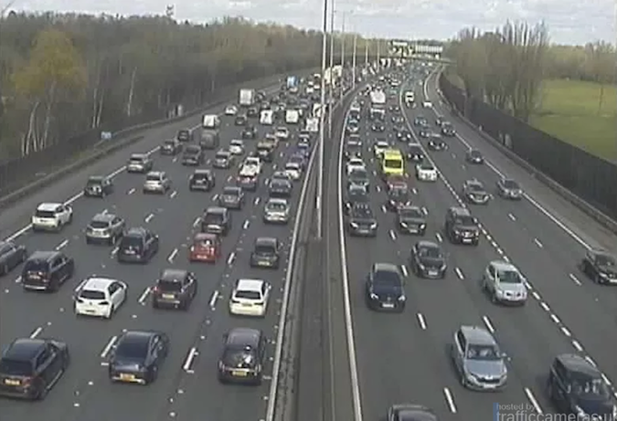

Sections of it became swamped with traffic soon after opening. The planners had underestimated the number of local journeys that would be made on what was supposed to be a long-distance motorway. The section near Heathrow has subsequently been built out to six lanes in each direction, hardly better than distributing the traffic around a few more purpose-built roads.
Ringway 3-and-a-half, the M25, has become part of London’s identity, one of the accepted ways of defining the capital: hello and welcome, Watford and Walton-on-Thames. When we cross it, even inner Londoners like me have a feeling of “nearly home”. The world beyond it can feel strange and hostile in this age of political polarisation. London is a concrete island within the M25 and, like Robert Maitland, we kind of like it that way.
Follow Lewis Baston on Bluesky. Main image (Dalston) from The London Archives. M25 photo from National Highways via Berkshire Live.
***
Footnote [1]: Robert Maitland’s timeline had already diverged from our own several years before 1973; Ringway construction had advanced further. The pedant may note that the Ringway project would not have created a junction exactly like the one described in Concrete Island. What I think Ballard has done is imagine an M4 spur starting near the Chiswick Roundabout, following the course of the North London Line through Acton and then smashing westwards through East Acton or Shepherd’s Bush to meet the Westway near where it intersects with Ringway 1, the West Cross Route.
Footnote [2]: The idea of building major roads including concentric urban motorways was an accepted feature of London’s planning ever since the 1944 Abercrombie Report. The growth of car ownership, projected forwards, would have brought central London to a complete halt unless something was done. Postwar London was a different and sparser city than our own; its population was falling, land was cheaper and there were bomb sites, slums and belts of decaying industry where new roads could be built.
Footnote [3]: One is at South Mimms where the carriageways to the east (Ringway 3) run separate from each other, anticipating Ringway 3 continuing round to Bushey and Northwood. The other is in the other corner, where the road billows out from Swanley to Sevenoaks. Junction 5 is peculiarly aligned where in both directions continuing round the M25 involves turning off to stay on (TOTSO in road-people parlance).
OnLondon.co.uk is funded in full by subscribers to publisher and editor Dave Hill’s twice-weekly newsletter On London Extra. To receive it, become a paying subscriber to Dave’s Substack or pay £50 a year or £5 a month through Support links on this site.